By: Chris Wolfe
I remember being thirteen, standing on the dock at Langskib as darkness fell. There in the distance we saw the lights of torches appear. The paddle butts beating the dock echoed the beating of excited hearts. The Bay Trip! The boys who got out of those canoes were giants in my eyes. I knew that somehow what they had just done was big. And there was the way people talked about the Bay Trip with a certain deference and respect- it all took on a kind of legendary quality. If you had told me then that in two years time I would be paddling in in one of those torch-bearing canoes, I don’t know if I would have believed you.
The first Bay trip left the dock of Langskib in 1975 and was out about 46 days, traveling over the Kippawa watershed down the Harricana river and across the bay to Moosonee where they all arrived despite having lost one of their canoes and all its contents. This of course was in a time before such luxuries as nylon tents and poly-pro.
The trip is named for James Bay, the southernmost tip of the Arctic ocean, but there is a river to paddle before one gets there. The Harricana has its source in the Blouin, De Montigny, Lemoine and Mourier lakes, close to Val-d’Or, and flows down draining a basin of 29,300 km². Our trips put in now in the town of Amos, Quebec. From there it is about 370 km down to the bay. Poplars on clay banks give way to the evergreens of the boreal. The banks become rocky and the river narrows. Each day has something memorable, even legendary- from the abandoned gold mines at Joutel, to Nudebathing Falls, to Spring Gorge, to the Bridge Set, to the Sign-in cabin, to Stormy’s Gorge, to One Mile Island, to Pink Rock, and to Seven Mile Island where many trips encounter challenges, as the river rushes over raging waterfalls, through ferocious rapids, and breathtaking gorges. Below Seven, as it approaches the Bay, the river cuts deep eskers, the topography flattens and the vegetation thins.
Many of the perils are behind, but paddling the 60 kilometers of open water across to the mouth of the Moose river and up to the town of Moosonee is no small order. Besides the tides that need to be taken into account, there’s no telling what weather may blow across the open water within minutes. The tidal flats go out until the shoreline is barely visible and there are few options for camping along the way. Trips have seen Beluga whales, and swells up to 28 feet have been recorded at the mouth of the Moose.
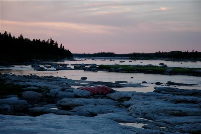
Most of my memories from my first trip down this river to the Bay are blurry. I do remember aching arms and back from the long stretches of flat water paddling at the top of the river. I remember being humbled by the power of the waters. I remember coming to rapids that could not be paddled with no trail to walk around. I remember the endless horizon when we reached the bay, a place of only sky meeting water. And I remember having the space to look inside myself to see where I was and where I wanted to go.
Trying to push through the bush with a canoe on my shoulders, lines catching and branches scratching, the land felt wild and untraveled. However this route along the Harricana to the bay has been traversed for many years, first by the Algonquins. In 1670, the Hudson’s Bay Company (HBC) was granted a charter by King Charles II, giving it a trading monopoly over the watershed of all rivers and streams flowing into Hudson Bay. But it was only 1801 Alexander MacKenzie mapped the entire route of the river for the first time and identified it by the name Harricanaw. In 1908, the first camps were established on its banks at the rapids. These were provisioning camps for the transcontinental railroad construction. A few years later, in 1910, the first colonists arrived and founded the town of Amos at the place where the railroad crosses the river.
When the route was traveled by those colonizers, they went up-stream bringing civilization into the wilderness. Now we are journeying in reverse, escaping civilization for the adventure of the wilderness. I believe as our lives get more and more “civilized”, there is something we are losing, something every young person hungers for. That something that cannot be learned in classroom or experienced through a video game. It can be found on the land, in the excitement of adventure, in the fear of uncertain outcome, and in the confrontation of one’s self, which can be so easy to avoid in a life with so many distractions.
I had the opportunity to go back to the Bay last summer, in a different capacity. Many of my memories from that first journey were blurred to the point that they had become much more story than experience, and that it was exciting to have their reality confirmed. Another memory that came last summer was the trust and faith I had had in my leaders; I knew that responsibility was something I now had to carry. It is a privilege and honor to be a part of such a journey, something I believe is so vital for a young person’s growth and development.